While the issues with loading and checking of moisture content have been well reported and to some extent would seem to remain tricky to overcome, other possible ways to mitigate the effects of weather on these at-risk vessels might be to make use of weather routing services.
Read more: The difficulties of enforcing regulations on the dangerous nickel ore trade
Speaking to Seatrade Maritime News, Stormgeo vp of Customer Service – Shipping George Schlinkert said that on the average voyage from Southeast Asia to China at least two factors can generate waves dangerous to a ship: these are tropical cyclones and frontal passages.
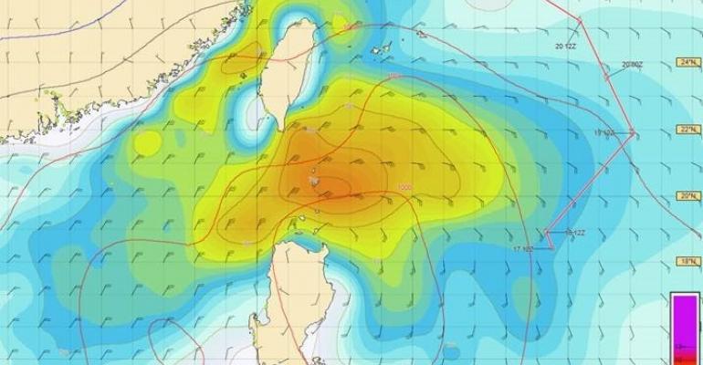
Giving critical insight into the factors at play, Schlinkert pointed out that as forecasting of storm tracks has improved, ships can now generally avoid tropical storms and typhoons. “Therefore, it is not necessarily encountering high winds and waves near the centre of a cyclone which will cause the problems, but rather the adverse conditions away from the centre,” he said.
In a possible scenario, he gave the example of a tropical low-pressure system over the Philippines where a ship north of Luzon might be considered to have successfully cleared the storm itself. However, it is clear (refer to chart showing significant wave heights) that very heavy conditions are extending well to the north of the low. The heaviest waves are being generated by the tight squeeze between the tropical low and the seasonal high pressure system which prevails over eastern Asia during the late autumn and winter seasons, Schlinkert pointed out.
While he acknowledged that these heavy conditions will likely be covered within high seas bulletins, Schlinkert noted that they can cover broad regions and this requires masters to be monitoring both cyclone bulletins as well as the relevant high seas bulletins, placing additional strain on resources.
Stormgeo’s Bon Voyage System (BVS), a graphical marine voyage optimisation system that provides on board and around-the-clock weather-routing information, puts all this information onto one platform, taking into account the track being sailed, and gives details on the conditions to be expected at the ship’s location.
Additionally, the master can see what conditions will be in the surrounding areas in order to ascertain whether alterations in course and/or speed would provide for better results.
Meanwhile as the season wears on, winter monsoon surges from Asia are linked to the passage of weakening cold fronts. In this scenario, once again, while conditions ahead of the front can be fairly benign, this can be followed by a rapid shift of conditions to the north and northeast, accompanied by high waves (as seen in the chart below).

In this example, as a weakening cold front from a developing gale extends towards the northern Philippines, 10-15 knot winds with low waves are rapidly replaced by 30 knot winds and waves of 4m or more. Schlinkert suggested that in this case, routing services could also help to pinpoint the time where these will occur and the master can be better prepared for the conditions to be expected.
“Depending on the scenario, course and speed adjustments can help to promote the safety of the ship and crew. It may be that waiting for a weather event to pass is the best option in terms of both safety and the time/fuel consumed,” he concluded.
Copyright © 2024. All rights reserved. Seatrade, a trading name of Informa Markets (UK) Limited.
Add Seatrade Maritime News to your Google News feed.  |


